- News & information
- About
- History
- George V. Voinovich
- George V. Voinovich Collection
- Calendar
- How to Find Us
- News
- Archives
- Photojournalism Fellowship Project
- Photo Essays
- Current Fellow
- Previous Fellows
- Reports and Publications
- Archives
- Students
- Prospective
- Center for Entrepreneurship
- Environmental Studies
- HTC/Voinovich School Scholars
- Master of Public Administration
- Current
- HTC/Voinovich School Scholars
- Center for Entrepreneurship
- Environmental Studies
- Master of Public Administration
- Alumni
- Contact
- School Leadership
- Strategic Partners Alliance
- Ohio University Public Affairs Advisory Committee
- Ohio University Public Affairs Advisory Committee
- Faculty and Fellows
- Faculty
- Visiting Professors
- Voinovich Fellows
- Professional Staff
in the Gwynns Falls Watershed, Baltimore County, Maryland:
Creation of a Suburban Social Ecology
Michael A. Wehling
M.A. Thesis, 2001
James M. Dyer
, Advisor
Department
of
Geography
Ohio University
Athens OH 45701
Summary While human reorganization of ecological functions has ancient origins, the pace and magnitude of global environmental change through urbanization is unprecedented. Knowledge derived from the long-term ecological research of Baltimore will help guide the management of urban areas to provide for ecological function and health, and greater understanding of global environmental functioning from an ecosystem scale case study.
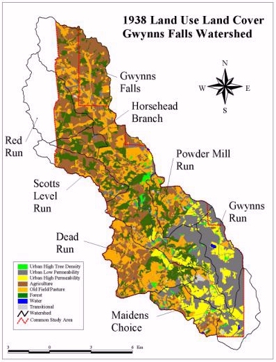
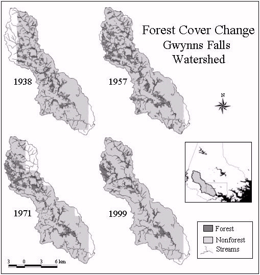
The primary goal of this study is to describe land use land cover (LULC) change emphasizing forest cover change in the Gwynns Falls Watershed of Baltimore County, Maryland during the 20th century. To accomplish this goal, this study
- maps the extent of LULC change by integrating air photos from 1938, 1957, 1971 and 1999, with a digitized forestry map from 1915 into a geographical information system (GIS)
- performs landscape pattern analysis on forest cover for each year
- overlays LULC maps in the GIS to determine change over time.
The Gwynns Falls Watershed transformed from an area covered by relatively equal proportions of Agriculture, Old Field/Pasture, Forest, and Urban-Low Permeability surfaces, to an area dominated by Urban-Low Permeability surfaces during the 20th century. The landscape within the Gwynns Falls Watershed underwent impressive changes in LULC exhibiting a dynamic nature. Between 1938 and 1957, 46% of the landscape in the common study area changed. Again, from 1957 to 1971, a 37% change in LULC occurred and between 1971 and 1999, 35% of the LULC shifted. Multiple and complex natural and social forces converged influencing the changes in the watershed. Transitions in agriculture allowed the expansion of forest cover onto old fields, similar to the larger pattern of the Eastern Deciduous Forest. Increasing development reduced and dispersed the Forest patches, potentially affecting species persistence and dispersal.
Forest cover in the Gwynns Falls Watershed reflects both the sociocultural and biophysical forces at work in the landscape. Human use of the watershed for agriculture, and later development, relegated the forest to riparian tracts where it persisted due to human values and physiographic properties. In contrast to Forest cover, the expansion of Urban-Low Permeability does not seem restricted by physiographic characteristics of the watershed. Instead, Urban-Low Permeability expands linearly from the City of Baltimore at the southern end of the watershed, northwest through the subsheds beginning with those in closest proximity to the city limits. The critical mass of people concentrated in the City of Baltimore expanded outward as population increased and technology and resources facilitated the swell of Urban-Low Permeability LULC. The character of this expansion changes after 1971 as biophysical processes at work in the human ecosystem interact with sociocultural processes bringing about a landscape more balanced among varied classes of LULC.
Through simultaneous and sequential
changes in agriculture, forest structure,
preservation, and urban expansion, both sociocultural and
biophysical
processes
transformed the LULC of the Gwynns Falls Watershed. Humans
affected
the ecological functioning of the watershed through the
transformation
of the landscape. Changing biophysical processes in turn
affected
humans living in the landscape and caused reactions in
sociocultural
processes.
Further inquiry into the reciprocal relationships of human
ecosystems
will
aid in understanding their functioning and management.


Additional maps and information about this project are available as a zipped PowerPoint slide, presented at the Baltimore Ecosystem Study 's 2001 Annual Meeting.
Questions can be directed to Jim Dyer. E-mail: dyer@ohio.edu .
Contact Information:
(740) 593–9381 | Building 21, The Ridges
Ohio University Contact Information:
Ohio University | Athens OH 45701 | 740.593.1000 ADA Compliance | © 2018 Ohio University . All rights reserved.
